


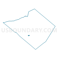
SPRING TWP DIST 02, Berks County, Pennsylvania
About
Outline

Summary
| Unique Area Identifier | 657376 |
| Name | SPRING TWP DIST 02 |
| County | Berks County |
| State | Pennsylvania |
| Area (square miles) | 0.52 |
| Land Area (square miles) | 0.52 |
| Water Area (square miles) | 0.00 |
| % of Land Area | 100.00 |
| % of Water Area | 0.00 |
| Latitude of the Internal Point | 40.32372100 |
| Longtitude of the Internal Point | -75.99057830 |
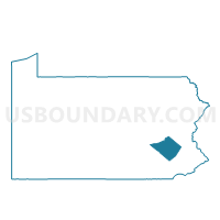
Maps

Graphs
Select a template below for downloading or customizing gragh for SPRING TWP DIST 02, Berks County, Pennsylvania


Neighbors
Neighoring Voting District (by Name) Neighboring Voting District on the Map
- SPRING TWP DIST 01, Berks County, PA
- SPRING TWP DIST 03, Berks County, PA
- SPRING TWP DIST 04, Berks County, PA
- WEST LAWN DIST 01, Berks County, PA
- WYOMISSING DIST 04, Berks County, PA
- WYOMISSING HILLS DIST 01, Berks County, PA
Top 10 Neighboring County Subdivision (by Population) Neighboring County Subdivision on the Map
Top 10 Neighboring Place (by Population) Neighboring Place on the Map
- Wyomissing borough, PA (10,461)
- West Wyomissing CDP, PA (3,407)
- West Lawn CDP, PA (1,715)
- Lincoln Park CDP, PA (1,615)
- Springmont CDP, PA (724)
Top 10 Neighboring Unified School District (by Population) Neighboring Unified School District on the Map
Top 10 Neighboring State Legislative District Lower Chamber (by Population) Neighboring State Legislative District Lower Chamber on the Map
Top 10 Neighboring State Legislative District Upper Chamber (by Population) Neighboring State Legislative District Upper Chamber on the Map
Top 10 Neighboring 111th Congressional District (by Population) Neighboring 111th Congressional District on the Map
Top 10 Neighboring Census Tract (by Population) Neighboring Census Tract on the Map
- Census Tract 109.03, Berks County, PA (6,205)
- Census Tract 111.02, Berks County, PA (5,459)
- Census Tract 109.05, Berks County, PA (4,594)
- Census Tract 110, Berks County, PA (4,588)